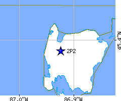
| FAA Identifier: |
2P2 |
| Lat/Long: |
45-23-17.7165N / 086-55-26.5450W
45-23.295275N / 086-55.442417W
45.3882546 / -86.9240403
(estimated) |
| Elevation: |
652.5 ft. / 199 m (estimated) |
| Variation: |
04W (2000) |
| From city: |
1 mile S of WASHINGTON ISLAND, WI |
| Time zone: |
UTC -5 (UTC -6 during Standard Time) |
| Zip code: |
54246 |
| Airport use: |
Open to the public |
| Activation date: |
02/1944 |
| Sectional chart: |
GREEN BAY |
| Control tower: |
no |
| ARTCC: |
MINNEAPOLIS CENTER |
| FSS: |
GREEN BAY FLIGHT SERVICE STATION |
| NOTAMs facility: |
GRB (NOTAM-D service available) |
| Attendance: |
UNATNDD |
| Pattern altitude: |
1652.5 ft. MSL |
| Wind indicator: |
lighted |
| Segmented circle: |
no |
| Lights: |
ACTVT LIRL RY 02/20; RY 14/32; WINDSOCK; WIIND TEE; ROTATING BCN - CTAF. |
| Beacon: |
white-green (lighted land airport)
ACTVT LIRL RY 14/32 & ROTATING BCN - CTAF. |
2P2 CTAF: |
122.9 |
| WX AWOS-2P2: |
118.52 (920-847-3024) |
| Nearby WX AWOS-3PT at 3D2 (19 nm SW): |
124.175 (920-854-5559) |
| Nearby WX AWOS - ESC (21 nm NW): |
121.425 (906-786-9001) |
| VOR radial/distance |
|
VOR name |
|
Freq |
|
|
Var |
| ESCr161/21.2 |
|
ESCANABA VOR/DME |
|
110.80 |
|
00E |
| MNMr068/33.0 |
|
MENOMINEE VOR/DME |
|
109.60 |
|
00E |
| NDB name |
|
Hdg/Dist |
|
Freq |
|
|
Var |
|
|
ID |
| STURGEON BAY |
|
036/39.2 |
|
414 |
|
03W |
|
SUE |
... ..- . |
| Parking: |
tiedowns |
| Airframe service: |
NONE |
| Powerplant service: |
NONE |
| Bottled oxygen: |
NONE |
| Bulk oxygen: |
NONE |
| Dimensions: |
2250 x 150 ft. / 686 x 46 m |
| Surface: |
turf, in good condition |
| Runway edge lights: |
low intensity |
| Gradient: |
S |
|
RUNWAY 2 |
|
RUNWAY 20 |
| Latitude: |
45-23.071500N |
|
45-23.407667N |
| Longitude: |
086-55.521500W |
|
086-55.301167W |
| Elevation: |
650.4 ft. |
|
643.1 ft. |
| Gradient: |
|
|
0.3% UP |
| Traffic pattern: |
left |
|
left |
| Runway heading: |
029 magnetic, 025 true |
|
209 magnetic, 205 true |
| Obstructions: |
44 ft. trees, 1200 ft. from runway, 200 ft. left of centerline, 27:1 slope to clear |
|
12 ft. road, 240 ft. from runway, 130 ft. left of centerline, 20:1 slope to clear |
| Dimensions: |
2232 x 150 ft. / 680 x 46 m |
| Surface: |
turf, in fair condition |
| Runway edge lights: |
low intensity |
| Gradient: |
NW. |
|
RUNWAY 14 |
|
RUNWAY 32 |
| Latitude: |
45-23.498833N |
|
45-23.204000N |
| Longitude: |
086-55.629167W |
|
086-55.318333W |
| Elevation: |
652.5 ft. |
|
636.2 ft. |
| Gradient: |
0.6% |
|
0.7% UP |
| Traffic pattern: |
left |
|
left |
| Runway heading: |
147 magnetic, 143 true |
|
327 magnetic, 323 true |
| Runway end identifier lights: |
no |
|
no |
| Touchdown point: |
yes, no lights |
|
yes, no lights |
| Obstructions: |
60 ft. trees, 800 ft. from runway, 140 ft. right of centerline, 13:1 slope to clear |
|
47 ft. trees, 1100 ft. from runway, 170 ft. left of centerline, 23:1 slope to clear |
| Ownership: |
Publicly-owned |
| Owner: |
TOWN OF WASHINGTON
P.O. BOX 220
WASHINGTON ISLAND, WI 54246
Phone 920-847-2522 |
| Manager: |
WALTER NEHLSON
1460 JACKSON HARBOR ROAD
WASHINGTON ISLAND, WI 54246
Phone 920-847-2147
ARPT PHONE 920-847-2448. |
| Aircraft based on the field: |
|
10 |
| Single engine airplanes: |
|
10 |
|
| - |
RY 14/32 +12' RISE IN RY ELEV NW 900 FT. |
| - |
NUMEROUS FLOCKS OF WATERFOWL & DEER ON & INVOF ARPT. |
| - |
RY 02/20 & RY 14/32 PLOWED WHEN SNOW IS OVER 3 INCHES. |
There are no published instrument procedures at 2P2.
Some nearby airports with instrument procedures:
3D2 - Ephraim-Gibraltar Airport (19 nm SW)
KESC - Delta County Airport (21 nm N)
KMNM - Menominee-Marinette Twin County Airport (34 nm SW)
KSUE - Door County Cherryland Airport (39 nm SW)
KISQ - Schoolcraft County Airport (47 nm NE) |